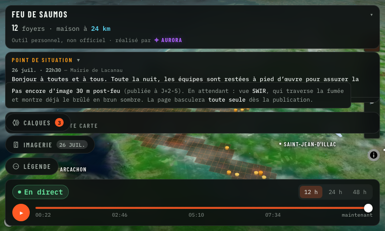
Suivi Feu Medoc is a real-time satellite map of the Saumos forest fire in Gironde, France. Hosted at https://suivi-feu-medoc.netlify.app/ and built by Aurora Studio, the tool layers NASA-detected hotspots, burned area, smoke plumes, water bomber aircraft tracks and wind forecasts onto a 3D Mapbox satellite view of the Médoc region.
The fire dataset comes from the VIIRS instruments aboard three NASA satellites (FIRMS program) which detect ground hotspots at 375-metre resolution. Smoke imagery is pulled from Meteosat, water bomber aircraft (Canadair, Dash and helicopters) are tracked via ADS-B transponders, and wind forecasts come from the ECMWF model. The map updates on every satellite pass with clear messaging when only stale data is shown.
Suivi Feu Medoc reads as a relief map: each 3D column is an active hotspot whose height and colour follow the radiated power in megawatts, the brown footprint is the cumulative burned area, smoke columns are draped over the imagery, and aircraft icons track the bombers in flight. Layers can be toggled individually and opacity is user-controlled. A "my distance to the fire" widget gives residents a quick check on proximity.
The tool is a personal project, not an official source. Suivi Feu Medoc points users to the préfecture de la Gironde and the mairie de Lacanau for evacuation orders and safety instructions. It is free, accessible without signup, and built in French for the local community around the fire.

Get Face Report is an AI-powered facial analysis and personal styling platform that helps users understand their facial features

Antique Scanner reads hallmarks, maker's marks and wear in your photos — and returns an honest identification with age and value ranges.

Turn Flat Images Into Editable Layers.
Turn any image into editable layers

Longruay - Official site: US$100 million, 30 days, one daily decision with AI briefings from Mira.

Life Path Calculator - trustworthy free numerology: verifiable math, honest Master Numbers, AI reading with refunds.
